
Geospatial Intelligence
From data acquisition and processing, to advanced analytics and data management, Airbus U.S. provides sophisticated geo-information services and turnkey integrated solutions that deliver exactly what customers need, when and where they need it.
Airbus U.S. WorldSAR Constellation
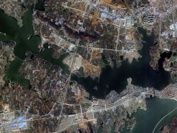
The TerraSAR-X family of Synthetic Aperture Radar (SAR) satellites (TerraSAR-X, TanDEM-X and PAZ) reliably acquire high-resolution and wide-area radar images, independent of weather and light conditions, and within a dusk/dawn orbit, which is outside of standard Electro Optical orbital patterns. The WorldSAR constellation orbits at a height of 514 km above the Earth and provides radar imagery to a wide variety of government, scientific and commercial users. The satellites feature a unique geometric accuracy that is unmatched by any other commercial space borne sensor. Image acquisition modes include Staring SpotLight, High Resolution SpotLight, SpotLight, StripMap, ScanSAR and Wide ScanSAR.
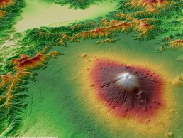
WorldDEM Digital Elevation Models
The first global elevation dataset with standardized 12-m coverage from pole to pole of the Earth. The data set is derived from stereo radar pairs collected by the twin satellites, TerraSAR-X & TanDEM-X. WorldDEM is a high-quality elevation layer that is free from common radar-induced anomalies and is the ideal solution for all mapping projects requiring accurate elevation models including orthorectification, floodplain determination, mineral exploration and hydrocarbon development, etc. Airbus U.S. has edited the entire global data set into a Digital Surface Model, which is available off-the-shelf.
RequestInformation
Request Information
Request Information